
Bulfinch Farm, 81 Strawberry Hill Road, Orford New Hampshire
(Provenance: aka Strawberry Hill and previously as the Abel Sawyer House)
Property Founding History and Provenance:
Early History: In December 1760, following the end of the French and Indian War, a number of the inhabitants of Hampton NH met to petition Governor Benning Wentworth” to form a township on the East Side of the Connecticut River at a place called ‘Sugar River.[1]’” Their petition was favorably received and the original proprietors (now numbering 63) received in October 1761 a Township Charter from King George the Third. Along with a significant number of township charters granted, New Hampshire charter number 7 was assigned to a six mile square tract along the Connecticut River, the Orford Charter in tribute to a companion town in England. (See Exhibit A)
The first proprietors or owners were entrepreneurial risk takers who promoted the settlements and helped to bring friends and neighbors up the Connecticut Valley. After the Governor granted himself 500 acres, and the proprietors laid out 50 acre “river lots” and later added 25 acres of upland pasture to themselves as detailed in the 1762 Proprietors’ Plan.[2]
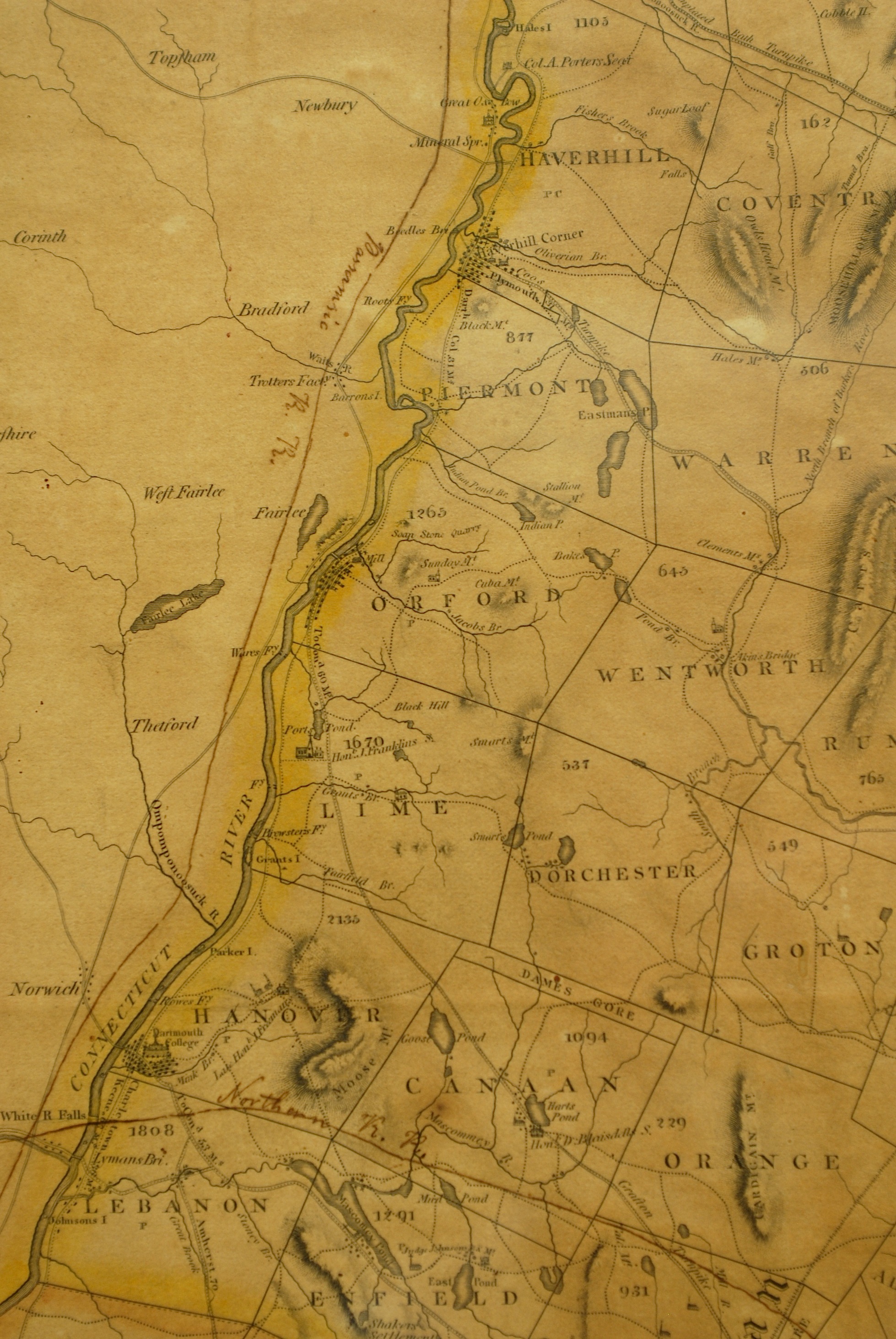
Exhibit A: 1818 Carrigan Region Map
Sawyer Family Arrival: The original settlers of Orford were Thomas Sawyer and his two sons who traveled 250 miles on horseback from Hebron Connecticut in the summer of 1765 to begin land clearing. Hebron neighbors, John Mann and his 18 year old new bride Lydia, followed later in the fall to become the first permanent settlers when they arrived October 24, 1765 and sheltered in the Sawyer built cabin. In June of 1766, Thomas Sawyer, his wife Hephzibah, a daughter by the same name and seven sons returned to Orford. The father of the underappreciated steamboat inventor (Samuel Morey), Israel Morey arrived with his family in January 1767. The new Orford settlers benefitted greatly from their reliance on long standing Native American trails that had been used for trading, farming and hunting.
One core Indian trail called “The Great Road” led from Charleston to Haverhill, and was later called the Dartmouth College Highway, now Route 10 through Hanover, Lyme and into Orford.[3] Orford Historical Society expert Carl Schmidt notes that “150 years ago, there were many more roads in Orford than there are today.”[4] However, road building on post glacial New Hampshire was very difficult yet many of the early settlers lived into their nineties![5]

Thomas Sawyer and his five boys were strong and dependable log cutters as require to fell 200 foot pine trees, many of which the King’s surveyors attempted to impound for British Navy masts.[6] (See Exhibit B- Tall Pines)

Sawyer Road now Strawberry Hill Road: Each of Thomas’s five boys were given land by their father. The eldest, Edward, built the first of many Sawyer homes in 1770 on what was known as Sawyer Road, halfway between Orford and Orfordville, as he had married an Orfordville girl named Hannah Strong in 1771.[7] The New Hampshire State Archives in Concord retain the oldest known roadmap of Orford from 1805 which reveals that the road connecting these two towns (now Route 25a) was a Native American travel route linking the Baker and Merrimack River valleys in the east to the Connecticut River valley in the west.[8] A secondary road also used by the Indians for east-west travel was Sawyer Road which passed northwest below Indian Pond.[9] (See Exhibit C)
Exhibit D: Grafton County Map Shows East West Access

But in 1788, Edward sold half his lot to each of his brothers, Abel and John. John had graduated from Dartmouth College in 1785- the same year his father died[10]– and then became Orford’s minister in 1787. John became very familiar with many personalities in Hanover and Boston, including architect Asher Benjamin who worked at the Bulfinch neo-classical and Federal building design firm. Abel had married Mary Strong, Hannah’s sister, in 1789 after he had completed construction of the original ell the year before. With the first bridge built across the Connecticut River at Orford in 1802, the chartering of the Grafton River Corporation by the state legislature in 1804, and the establishment of the northern terminus of the Grafton Turnpike (toll road) in 1806, Orford suddenly was a minor gateway to the west. Today’s Route 10 coupled with Rt 25a represented the best road providing a natural gap between the mountains in order to cross the state. By 1830, Orford’s population was 1,896, nearly twice its current number.
Exhibit E: 1800s Bring “Go West” Turnpike Corporations – Orford’s Access

Bulfinch Provenance: Abel’s expansion of the original 1788 ell started in 1806 when he dug a cellar and laid a granite foundation that is dated June 1806.[11] Two years later, the expansion was completed with a Bulfinch-style fanlighted front doorway and by 1810, at age 59, Abel divided his farm with his son, Jonathan Strong Sawyer. Abel continued to work the farm for many years and died in 1845 aged ninety-two.
[1] Conant, William R., Orford History, p. 19, August 25, 1915.
[2] Ibid, Conant, p. 16.
[3] Schmidt, Carl, “Exploring Orford’s Roads Less Traveled,” Orford Historical Society, October 4, 2009.
[4] Ibid, Schmidt, p.1.
[5] Conant, Louis, Report of the Bicentennial Celebration of the Town of Orford, New Hampshire, August 7 & 8, 1965, p.58.
[6] Hodgson, Alice Doan. Thanks to the Past. The Story of Orford, New Hampshire. Orford, NH, Historical Facts Publications, 1965, p. 182.
[7] Ibid, Doan, p. 180.
[8] Schmidt, Carl, “Exploring Orford’s Roads Less Traveled,” Orford Historical Society, October 4, 2009.
[9] Ibid, Schmidt.
[10] Hodgson, Alice Doan. Thanks to the Past. The Story of Orford, New Hampshire. Orford, NH, Historical Facts Publications, 1965, p. 182.
[11] Ibid, Doan, p. 187.
